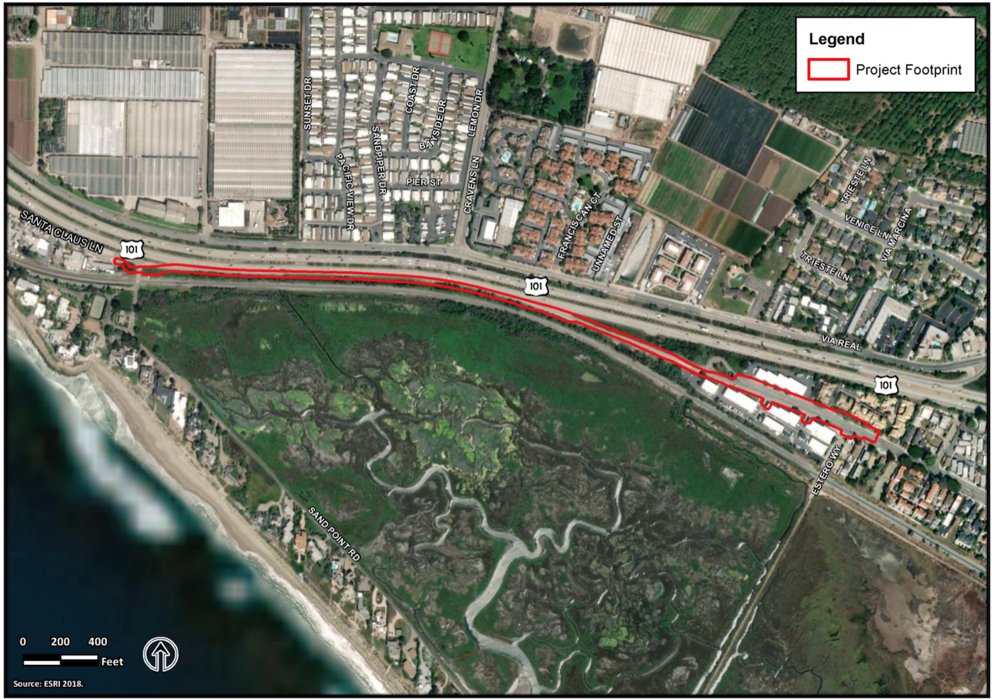
Santa Claus Lane Bike Project

Residents have until January 6, 2020 to comment on a proposed project to construct a bike path adjacent to southbound lanes of Highway 101 between Estero Street in Carpinteria and Sand Point Road in unincorporated Santa Barbara County. The project, which has been planned for several decades and is in both the City of Carpinteria and County of Santa Barbara’s long range plans, is part of a series of independent transportation improvement projects that are proposed along the 101 corridor, including the widening project that will add a third lane in both directions.
The proposed bike path, which would be for the exclusive use of bikes and pedestrians, is .8-mile in length and would ultimately be a part of the California Coastal Trail, which is a network of public trails along the California coastline. Currently, between Santa Claus Lane and Carpinteria Avenue, bicycle traffic is diverted inland via Padaro Lane, Via Real, and Santa Ynez Avenue; there is currently no continuous, direct route along the coast, which creates a gap in the California Coastal Trail. Some portions of the existing route are not wide enough to accommodate standard bicycle lanes, and bicyclists must compete with vehicular traffic for space along the route, according to the project’s Mitigated Negative Declaration.
The project is bound by the Union Pacific Railroad tracks to the south, and Highway 101 to the north. (Though Highway 101 is designated as a north-south corridor, it is situated in an east-west direction within the project area; the northbound lanes run in a western direction and southbound lanes run in an eastern direction.) The project area includes the Carpinteria Salt Marsh, which is directly adjacent to and south of the Union Pacific Railroad tracks.
The two-lane bike path would include a four-foot northbound (westbound) lane, a four-foot southbound (eastbound) lane, and varied shoulder width of approximately two feet on each side, for a total width of approximately 12 feet. The bike path would be constructed almost entirely within Caltrans right of way, and no permanent right of way would be required from Union Pacific Railroad; however, a temporary construction easement would be required from Union Pacific Railroad to facilitate construction of the retaining wall. A limited portion of the bike path would be constructed in city right of way at the Estero Street connection point. The bike path would be profiled at approximately the same elevation as the southbound lanes of Highway 101, and it has been designed to avoid impacts to coastal wetlands to the extent feasible. Wall-mounted lights may be installed approximately 2.5 to three feet above the bike path surface. If used, lighting would consist of low-level lighting fixtures to enhance public safety, according to the report.
The project is expected to cost $8,150,000, with funding from a combination of sources including funds from Measure A and SB1. The project is being proposed by Caltrans, in cooperation with the Santa Barbara County Association of Governments, City of Carpinteria, and Santa Barbara County. Currently in the environmental phase, these entities are asking for public input on the Mitigated Negative Declaration until Monday, January 6. Design is expected to be completed late 2020, with construction to begin late 2021, and construction complete in 2022/2023.
For more information, and to comment, visit www.dot.ca.gov/caltrans-near-me/district-5/district-5-current-projects/santa-claus-lane-bike-path.


