Planetary Analogs: Or Where on Earth is Mars?

Now that it’s spring and we’re starting to travel again, our local deserts have become popular nearby attractions. Joshua Tree, Death Valley, and the Mojave Desert are at their best this time of year and you might even catch some wildflowers if they got enough rain. At NASA, in addition to enjoying seasonal wildflowers, we often employed our local deserts as stand-ins for different planets.
My career at NASA’s Jet Propulsion Lab was involved mainly with developing new ways of studying the Earth from space, in particular the Earth’s landscapes and how they’ve evolved over geological time. At the same time, we all realized that the technologies we were developing could be used to study the other planets and moons of the solar system, so we spent a lot of time thinking about how to apply what we learned on the Earth to other, far-flung places. In the early days of the development of geological applications of satellite remote sensing, we often took the new images acquired from the satellites or airborne test beds out to the field in order to understand what the satellites were seeing. For geological applications, we chose areas with little vegetation, which tends to obscure the underlying landscape.
As we learned more about how to interpret data from the various instruments, we started comparing our field sites to geological features on other planets like Mars, at which new missions were showing features just like the Earth: sand dunes, dry river valleys, playas, volcanoes, and meteor craters. At the same time, engineers developing missions to Mars were looking for environments similar to what their landers and rovers would encounter. As a result, I started leading groups out to our sites to show the engineers and scientists how we could use the sites to simulate Martian landscapes and to help us understand the data sent back from missions to the red planet. It was fun and gratifying to show engineers who wanted to send instruments to Mars, but had never visited a desert, what rocks and dirt actually looked like! Highlights included leading Space Shuttle astronauts out to our sites before they flew on missions that included instruments developed at JPL for Earth and planetary geological study.
Over the years, several sites in California and Nevada stood in for Mars and other planets: Death Valley, Kelso Dunes, sand dunes at the Salton Sea, Pisgah and Amboy craters, the Cima volcanic field in the Mojave Desert, and the Nevada Test Site.
Death Valley was one of our earliest test sites due to the variety of landscapes and lack of vegetation. One of my first jobs at JPL back in the ’70s was helping test a thermal infrared instrument to be flown on an aircraft. Because this early sensor lacked sensitivity, the principal investigator chose summer for our field calibration campaign in order to have the maximum temperatures! We worked in the early morning and evening, hiding out in the air-conditioned cabins at Furnace Creek Ranch with the car-company engineers who were testing their new models. Death Valley also contains sand dunes and a small volcanic explosion crater – features also found on Mars – and giant alluvial fans that form as water washes gravel from the steep Panamint Mountains to the west. The Shuttle astronauts were good ‘students’ as I described how the fans formed, and I was particularly pleased when they called down from orbit a few months later for the CapComm to “tell Dr. Farr that we can see those beautiful alluvial fans as we fly over Death Valley.” An eroded alluvial fan deposit sits at the exit from the Artist’s Drive loop in Death Valley, and after the first images from the surface of Mars were obtained by the Viking landers in 1976, we realized that that small hill looked exactly like the lander pictures. We dubbed it “Mars Hill” and many others have stopped by for a selfie on Mars over the years.
Kelso Dunes is a large sand dune complex situated in the Mojave Desert Preserve, south of Baker. Being close to JPL, we often used it to learn more about how our instruments ‘saw’ sand dunes. One of my professors at Caltech, Robert Sharp, studied them and other dunes. He and others developed an understanding of how the form of the dune can tell us something about the wind regime and the supply of sand. These two parameters decide whether you have a star dune like Kelso where a large supply of sand combines with multiple directions of wind to pile up the sand in one big stack, or linear dunes, common in the Sahara where the wind comes from only one direction, or crescentic barchan dunes for which the wind comes from only one direction, but limited sand supply yields scattered dunes migrating across the landscape. A nice example of barchans is on the southwest shore of the Salton Sea.
A colleague from JPL, Serina Diniega, who models geological processes on other planets, conducted an interesting experiment at Kelso Dunes a while back, which I joined up with. She was interested in whether shallow gullies on Mars could have been made by blocks of dry ice (frozen CO2) sliding down dune faces. We brought some dry ice blocks to the summit of the dune and sure enough, they sledded down on a curtain of gas! Serina wants to be the first astronaut to snowboard down a dune on Mars! (Search “Dry Ice Moves on Mars” on YouTube.)
Model Volcanoes and Craters
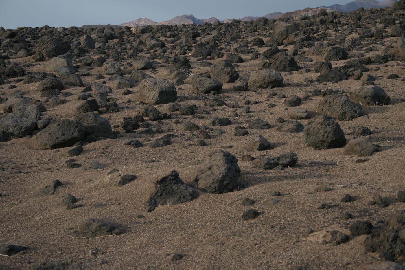
Volcanoes are also common on other planets, so we’ve spent time on some of our local examples in the Mojave Desert. Pisgah Crater is located off of Interstate 40 east of Barstow, and Amboy Crater is a little further east along old Route 66. They’re also associated with playas, or dry lake beds, another landform found on other planets. Much of Pisgah Crater and its lava flows and playa lie within the Twentynine Palms Marine Base, which led to some interesting field visits, especially when they forgot we had permission to be on the bombing range! Engineers used the lava flows to test penetrators, planned to be dropped from orbit and to hard-land on Mars. Many interesting volcanic features are found at the two lava fields, including cinder cones, different types of lava surfaces, and lava tubes, which are found on the Moon, Mars, and probably volcanic fields on other planets.
Cima volcanic field is an extensive complex of volcanoes, cinder cones, and lava flows in the Mojave Desert Preserve between Kelso Dunes and Baker. Researchers from the U.S. Geological Survey and some universities did an extensive study of the rate of landscape change there as calibrated by the lava flows of various ages. I piggy-backed on their studies to look at how the flows changed in appearance to our different remote-sensing instruments. I also led many field trips through the area. For a long time, there was a strange, lonely telephone booth at the junction of two rough dirt roads in the middle of nowhere, which rarely saw any vehicles. We called it Superman Junction. One day, while I was expounding on some feature of the geology of the area to a group of students, the phone rang. One of the French post-docs answered it and began speaking in French! It turned out the phone had become famous on social media as the ‘Mojave Phone Booth’ and the caller was calling from France! Sadly, the phone company removed the phone booth a number of years ago.
Finally, meteor impact craters are very important on other planets, but are often weathered away on Earth. A famous one is in Arizona and has been studied extensively. I wanted to find some fresher ones to study with some of our more advanced remote sensing techniques and realized that explosion craters are much like hyper-velocity impacts – as the meteor typically penetrates deeply before exploding. I applied for and received permission to fly aircraft equipped with an advanced imaging device and a laser altimeter called Lidar to make detailed topographic maps of several explosion craters at the Nevada Test Site. We were also allowed to do field work there and visited several nuclear test sites, as well as conventional explosion craters. At one point, far in the north of the Test Site, we had a good view to the north at Area 51. We were instructed to take no photos in that direction.
Using the Earth as a stand-in for other planets can have its pitfalls. We’ve found landforms on Mars that have no analog on Earth and vice-versa. We always have to remind ourselves that Mars’ atmosphere is extremely thin – about the same as 100,000 feet on Earth, and its gravity is only about 40% of Earth’s. So the same geological processes can produce different landforms on Mars. Those dry-ice sleds are an example. So we usually concentrate on the process rather than the landform, such as interpreting sand dunes as a function of wind direction and sand supply. Still, it’s a thrill to have so many other-worldly sites in our backyard. So if you happen to find yourself in Death Valley or at the top of Kelso Dunes, put on your rose-colored glasses and imagine you’re standing on Mars instead!
Tom Farr joined NASA’s Jet Propulsion Laboratory in 1975 and has helped develop the first geologic applications of imaging radar using aircraft, satellites, and the Space Shuttle. He currently resides in Montecito and has taught a class on planetary exploration at SBCC for more than 10 years.


