
New Storm Map to be Released
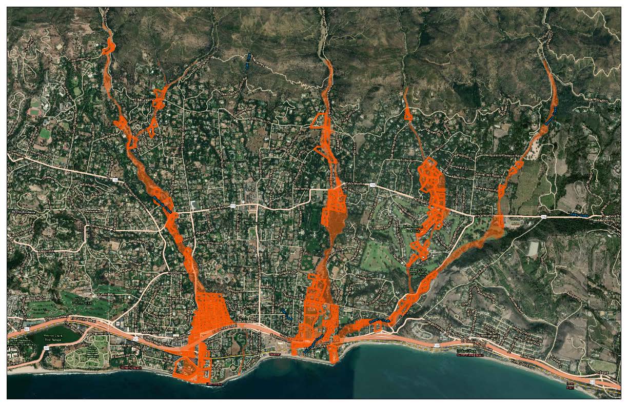
This Thursday, December 17, the Montecito Fire Department, in partnership with the Santa Barbara County Office of Emergency Management (OEM), the Carpinteria Summerland Fire Protection District, and First District Supervisor Das Williams will host a virtual community meeting to provide winter preparedness information and to publicly release the updated Interactive Storm Impact Consideration Risk Map. This map is a new iteration of the map released this time last year; it identifies properties in our local community that may be at risk from debris flow or flooding this storm season.
We sat down with Montecito Fire Chief Kevin Taylor earlier this week to discuss the new map, and what it means for future flood warnings and potential evacuations. With three years of growth on our watershed, and our fourth winter since the Thomas Fire (December 2017), it is estimated that there is 80-90% of the canopy cover in the upper watershed, as analyzed by biologist Kevin Cooper. “We expect the watershed to tolerate this year’s storms at least as well as 2020,” Taylor optimistically said, while being clear that Montecito is still at risk for debris laden flooding, as evidenced in 1969, when Montecito suffered a significant debris flow five years after the Coyote Fire of 1964. “The soil is recovering but it’s not at pre-fire conditions,” he said, adding, “Our community will remain at risk for up to five years after the Thomas Fire.”
This new map, to be released to the public following Thursday evening’s meeting, identifies 445 parcels in the “red zone,” meaning they are at risk for flooding during certain wet weather events. These properties are adjacent to waterways, or are downstream from areas in which obstruction of a waterway or creek channel may occur. The 445 parcels is down from 517 identified in 2019, and 1,568 identified in 2018. “As the amount of material available for mobilization decreases, the likelihood of the debris flow expanding beyond the existing creek channels decreases as well,” Chief Taylor said. The reduction in parcels on the map is evident along several creek channels, including San Ysidro Creek through the Hedgerow, Romero Creek on the south side of the 101, and Montecito Creek in the Olive Mill/Coast Village roads area, as well as below the 101. The map, as always, is interactive, and users will be able to type in their address to see if their property is in a red zone.
As was the case this past winter season, there will be no set rain amount threshold to determine an evacuation this winter; evacuations will be determined from a combination of factors. If there is a prolonged “saturation event,” which is defined as 8 to 10 inches of rain in 2-3 days, which is followed by or includes a high intensity, short duration rainfall, an evacuation may be ordered. But it will also be dependent on the status of the debris basins and creek systems; the District, OEM, and County Flood Control continually monitor the creeks, debris basins, and debris nets during weather events, to see if everything is holding up well. They also monitor the choke points including bridge culverts, sharp turns in the creeks, and drainage pipes. “No two storm events are the same, and the watershed responds differently each time,” the Chief explained.
Potential evacuations could be localized to one area of Montecito, they could include only the “red zone” on the map, or they could comprise the entire community, depending on the severity of the situation. “We’ll continue to communicate our decision making process as we move through the storm season. If we are considering an evacuation or order, we will notify those on the red area on the map. All of this will occur in an open and transparent manner,” Chief Taylor said. “Our number one goal is to keep the community safe.” This past rainy season, there were no evacuations warnings or orders issued, despite some significant storms in late March and early April. “The watershed tolerated those storms well, which was encouraging,” Chief Taylor said.
The regrowth of the vegetation in the watershed, the cleared out debris basins and channels, and the ring nets above Montecito have all contributed to the development of the map, which was a collaboration between multiple local emergency agencies as well as several consultants and weather experts. On Thursday, the virtual Community Meeting will include speakers Kevin Cooper, who will discuss the watershed regrowth, Eric Bolt from the National Weather Service, Jon Frye from County Flood Control, Craig Bonner from the Sheriff’s Department, Kelly Hubbard from OEM, and Chief Taylor.
For information on how to join the virtual meeting, call 969-7762. The meeting is on Thursday, December 17, at 5:30 pm.
Even as we prepare for the winter storm season, Montecito’s wildfire threat is always looming. With recent sundowner winds, low humidity, and no recent rainfall, fire continues to be a real threat to our community. Chief Taylor explained that fire can easily carry from our local foothills into our communities, even this soon after a massive fire like the Thomas Fire. “A normal return interval in our mountain ranges is twelve to fifteen years after a fire,” Chief Taylor said. “However, that was before the ‘new normal’ that we are now experiencing. All bets are off, and we are still at risk even in very young vegetation.”
To learn more about wildfire preparedness, visit www.montecitofire.com.


